


130 items
The Jatun Sacha Foundation is a private Ecuadorian non profit NGO (nongovernmental organisation) founded in 1985. The purpose of this organisation is outlined on its website as:
San Pedro de Suma ist eine Ortschaft und eine Parroquia rural („ländliches Kirchspiel“) im Kanton El Carmen der ecuadorianischen Provinz Manabí. Die Parroquia besitzt eine Fläche von 189,61 km². Die Einwohnerzahl lag im Jahr 2010 bei 6692. Die Parroquia wurde am 12. November 1999 gegründet. Neben dem gleichnamigen Hauptort und Verwaltungssitz (cabecera parroquial) gibt es 41 Recintos in dem Verwaltungsgebiet.
Wilfrido Loor Moreira ist eine Parroquia rural („ländliches Kirchspiel“) im Kanton El Carmen der ecuadorianischen Provinz Manabí. Die Parroquia besitzt eine Fläche von 290,4 km². Die Einwohnerzahl lag im Jahr 2010 bei 4586. Die Parroquia wurde am 28. Mai 1991 gegründet. Namensgeber war Wilfrido Loor Moreira (1900–1984), ein ecuadorianischer Rechtsanwalt, Schriftsteller und Historiker.
Chibunga ist eine Ortschaft und eine Parroquia rural („ländliches Kirchspiel“) im Kanton Chone der ecuadorianischen Provinz Manabí. Die Parroquia besitzt eine Fläche von 570,8 km². Die Einwohnerzahl lag im Jahr 2010 bei 6360. Die Parroquia wurde am 4. August 1988 gegründet.
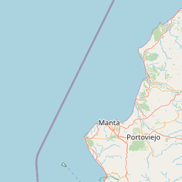
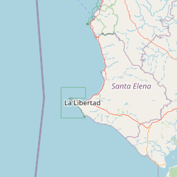
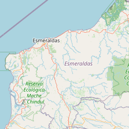
The meridian 80° west of Greenwich is a line of longitude that extends from the North Pole across the Arctic Ocean, North America, the Atlantic Ocean, the Caribbean Sea, Panama, South America, the Pacific Ocean, the Southern Ocean, and Antarctica to the South Pole.
The 1942 Ecuador earthquake or the Guayaquil earthquake occurred on 13 May at 21:13 local time with a moment magnitude of Mw 7.9. The temblor struck the coastal (Esmeraldas) region of Manabí Province, Ecuador. It caused damage mainly to cities including Guayaquil, Portoviejo and Guaranda. More than 300 people were killed and the total cost of damage was about US$2.5 million (1942 rate). Ecuador's largest city Guayaquil was the most affected despite the significant distantce from the epicenter. Many reinforced concrete structures in a particular area in the city were completely destroyed, contributing to fatalities.
Convento es un pueblo y una parroquia rural ecuatoriana del cantón Chone en la provincia de Manabí.[1] Fue fundada el 25 de junio de 1954 y su población era 6578 habitantes en 2010.[2]
La narcoavioneta Cessna T210 accidentada en Manabí, Ecuador,[1] fue una avioneta mexicana que contenía enormes cantidades de dinero y que era utilizada para el contrabando y tráfico de droga, que se dirigía a un laboratorio ilícito de la costa central de Ecuador, en la provincia de Manabí y que se estrelló cerca de Pedernales el 13 de mayo de 2012.
Jama est une ville située en Équateur, dans la province de Manabí. Elle est le chef-lieu du canton de Jama.
The Jama Formation is a Pliocene to Early Pleistocene (Montehermosan to Ensenadan in the SALMA classification) geologic formation in Ecuador. The claystones and sandstones were deposited in an coastal environment. The age of the Jama Formation is constrained by 40Ar/39Ar dating of tephra beds. The formation is correlated to the Charco Azul Formation of western Panama and southeastern Costa Rica.
Ricaurte ist eine Ortschaft und eine Parroquia rural („ländliches Kirchspiel“) im Kanton Chone der ecuadorianischen Provinz Manabí. Die Parroquia besitzt eine Fläche von 361,7 km². Die Einwohnerzahl lag im Jahr 2010 bei 7920. Die Parroquia Ricaurte wurde am 20. September 1907 gegründet. Vermutlich wurde die Ortschaft und die Parroquia zu Ehren des südamerikanischen Unabhängigkeitskämpfers Antonio Ricaurte benannt.
Eloy Alfaro ist eine Ortschaft und eine Parroquia rural („ländliches Kirchspiel“) im Kanton Chone der ecuadorianischen Provinz Manabí. Die Parroquia besitzt eine Fläche von 327,7 km². Die Einwohnerzahl lag im Jahr 2010 bei 7832. Die Parroquia wurde am 7. Juni 1919 gegründet. Namensgeber war Eloy Alfaro, 1895–1901 und 1906–1911 Präsident von Ecuador.
The 1998 Bahía de Caráquez earthquake occurred on August 4 at 13:59 local time (18:59 UTC) with a magnitude Mw 7.2. The epicenter was located at 10 km north of Bahía de Caráquez, about 190 km NNW of Guayaquil, and about 215 km W of Quito, Ecuador. The intensity in Bahía de Caráquez reached MM VIII. In Bahía de Caráquez, electricity, telephone, and water services disrupted, and many buildings were damaged. It was felt strongly in Guayaquil and Quito and could be felt in much of Ecuador and in Cali, Colombia. An Mw 5.4 foreshock occurred 1 hour and 24 minutes before the main shock and hence alerted many people. The Nazca Plate is subducting beneath the South American Plate near the Ecuadorian coast. This earthquake was a shallow thrust earthquake in this subduction zone.
Según la historiografía ecuatoriana, se denominaría Gobierno de Caráquez o Gobierno de La Canoa a todos los territorios de la zona norte de Manabí en tiempos de la dominación española en América, a partir del año 1562 hasta 1824. Dichos gobiernos se ubicaron en la región litoral de la Real Audiencia de Quito, cuya jurisdicción sobre ellos fue producto de su anexión dentro de lo que se conoce como la Conquista del Perú, localizados como parte de la Provincia de Puerto Viejo y señoríos de la Provincia de Coaque en la Gobernación de la Nueva Castilla hacia 1529; seguidamente hasta la creación del Virreinato del Perú en 1542. Posteriormente estos territorios fueron incorporados al Virreinato de la Nueva Granada tras su creación en 1717, anulación en 1723 y restauración en 1739. Todas sus comarcas y poblados indígenas y mestizos desde siempre se sujetaron territorialmente a la Real Audiencia de Quito y legalmente asumían y obedecían disposiciones del Corregimiento de Quito con sede judicial y política en la ciudad de San Francisco de Quito.
La Manga del Cura is a territory located in the Manabí Province belonging to the canton El Carmen in Ecuador.
Canuto ist eine Ortschaft und eine Parroquia rural („ländliches Kirchspiel“) im Kanton Chone der ecuadorianischen Provinz Manabí. Die Parroquia besitzt eine Fläche von 198,3 km². Die Einwohnerzahl lag im Jahr 2010 bei 10.355.
Quiroga ist eine Ortschaft und eine Parroquia rural („ländliches Kirchspiel“) im Kanton Bolívar der ecuadorianischen Provinz Manabí. Die Parroquia besitzt eine Fläche von 61,97 km². Die Einwohnerzahl lag im Jahr 2010 bei 3767. Die Parroquia wurde am 29. Juni 1956 gegründet.
La Escuela Superior Politécnica Agropecuaria de Manabí "Manuel Félix López", ESPAM MFL, es una universidad pública ecuatoriana ubicada en la ciudad de Calceta, Cantón Bolívar, es la principal universidad de la zona norte de la provincia de Manabí.
website: http://www.espam.edu.ec/
The Manabí mangroves (NT1418) is an ecoregion along the Pacific coast of Ecuador. The mangroves serve important functions in the marine and terrestrial ecology. They have been severely degraded and fragmented, particularly in the northern region. Construction of shrimp farms caused much damage in the past, but is now banned. Sedimentation caused by overgrazing in higher lands is an issue, as are human activities such as port and highway construction, urbanization, waste disposal and so on.
La Refugio de Vida Silvestre Isla Corazón y Fragatas es un área protegida del Ecuador. Se encuentra ubicada en la provincia de Manabí. Fue declarado área protegida en 2002. Tiene una extensión de 2811 hectáreas. El área protege los últimos remanentes de manglar que quedan en el estuario.[1]
Chirijos ist eine Ortschaft und eine Parroquia rural („ländliches Kirchspiel“) im Kanton Portoviejo der ecuadorianischen Provinz Manabí. Die Parroquia besitzt eine Fläche von 74,7 km². Die Einwohnerzahl lag im Jahr 2010 bei 2362. Chirijos gehörte früher zur Parroquia Alhajuela. Die Parroquia Chirijos wurde am 7. August 1996 gegründet.
La Unión ist eine Ortschaft und eine Parroquia rural („ländliches Kirchspiel“) im Kanton Santa Ana der ecuadorianischen Provinz Manabí. Die Parroquia besitzt eine Fläche von 232,6 km². Die Einwohnerzahl lag im Jahr 2010 bei 6466. Die Parroquia wurde am 7. Dezember 1883 gegründet. Ein Jahr darauf wurde die Parroquia vom Kanton Portoviejo an den neu gegründeten Kanton Santa Ana übertragen.
Honorato Vásquez ist eine Ortschaft und eine Parroquia rural („ländliches Kirchspiel“) im Kanton Santa Ana der ecuadorianischen Provinz Manabí. Die Parroquia besitzt eine Fläche von 156,2 km². Die Einwohnerzahl lag im Jahr 2010 bei 5886. Die Parroquia wurde am 21. November 1938 gegründet. Namensgeber war Honorato Vásquez Ochoa (1855–1933), ein ecuadorianischer Anwalt, Diplomat, Schriftsteller und Dichter.
Anona is a place in Jipijapa, Manabí Province, Ecuador, South America.
Christ the King School (Spanish: Unidad Educativa Cristo Rey) is a private Catholic primary and secondary school, located in Portoviejo, Ecuador. Established in 1930 as a seminary run by the Society of Jesus, the school grew to be pre-primary through high school, and serves the needier segment of society.
website: https://translate.google.com/translate?hl=en&sl=es&u=http://www.cristorey.edu.ec/&prev=search
The Technical University of Manabí (UTM), is a public institution of higher education located in the city of Portoviejo, Manabí, Ecuador. It was founded on October 29, 1952, in the presidential government of Dr. José María Velasco Ibarra. Its three substantive functions are: scientific research, the academy and relationship with society; intervenes with quality in all spheres and sectors, both public and private, through the support of students, teachers and authorities. It offers undergraduate and postgraduate studies in various specialties and modalities.
The Roman Catholic Metropolitan Archdiocese of Portoviejo (Latin: Archidioecesis Portus Veteris) is an archdiocese located in the city of Portoviejo in Ecuador.
website: http://www.arquidiocesisportoviejo.org/
El Jardín Botánico de Portoviejo es una zona preservada, jardín botánico, arboreto, Orquideario, palmetum y área de rescate. El Área de Reserva tiene 37 hectáreas; área Jardín botánico 10 hectáreas, área Centro de Rescate 3 hectáreas, lo que hace un total de 50 ha de extensión, propiedad de la Universidad técnica de Manabí, que se encuentra en el trópico occidental del Ecuador, en la ciudad de Portoviejo.
Pueblo Nuevo (span. für „Neues Dorf“) ist eine Ortschaft und eine Parroquia rural („ländliches Kirchspiel“) im Kanton Portoviejo der ecuadorianischen Provinz Manabí. Die Parroquia besitzt eine Fläche von 36,54 km². Die Einwohnerzahl lag im Jahr 2010 bei 3169. Pueblo Nuevo war ursprünglich ein Recinto in der Parroquia Riochico. Am 24. Februar 1953 wurde die Parroquia Pueblo Nuevo gegründet.
Riochico ist eine Kleinstadt und eine Parroquia rural („ländliches Kirchspiel“) im Kanton Portoviejo der ecuadorianischen Provinz Manabí. Die Parroquia besitzt eine Fläche von 82,67 km². Die Einwohnerzahl lag im Jahr 2010 bei 11.757. Die Parroquia wurde am 13. Mai 1861 gegründet.
La Catedral Metropolitana de Portoviejo oficialmente Catedral Metropolitana de Jesús el Buen Pastor es una catedral ecuatoriana que se encuentra ubicada en la calle Alajuela entre la Ave. Universitaria y Morales, frente al parque Eloy Alfaro de Portoviejo en Ecuador.[1][2]
Membrillal ist eine Ortschaft und eine Parroquia rural („ländliches Kirchspiel“) im Kanton Jipijapa der ecuadorianischen Provinz Manabí. Die Parroquia besitzt eine Fläche von 67,8 km². Die Einwohnerzahl lag im Jahr 2010 bei 1005. Die Parroquia wurde am 31. Juli 1986 eingerichtet.
The Tablazo Formation is a Middle Pleistocene geologic formation of Santa Elena Province in western Ecuador. The claystones and sandstones were deposited in an estuarine environment.
Santa Marianita, auch als Pacoche bekannt, ist eine Ortschaft und eine Parroquia rural („ländliches Kirchspiel“) im Kanton Manta der ecuadorianischen Provinz Manabí. Die Parroquia besitzt eine Fläche von 38,31 km². Die Einwohnerzahl lag im Jahr 2010 bei 2708. Die Parroquia wurde am 18. November 1996 gegründet.
The Ecuadorian dry forests (NT0214) is an ecoregion near the Pacific coast of the Ecuador. The habitat has been occupied by people for centuries and has been severely damaged by deforestation, overgrazing and hillside erosion due to unsustainable agriculture. Only 1% of the original forest remains. The patches of forest, mostly secondary growth, are fragmented. They are home to many endemic species at risk of extinction.
Bellavista ist eine Ortschaft und eine Parroquia rural („ländliches Kirchspiel“) im Kanton 24 de Mayo der ecuadorianischen Provinz Manabí. Die Parroquia besitzt eine Fläche von 103,1 km². Die Einwohnerzahl lag im Jahr 2010 bei 4920. Die Parroquia Bellavista wurde am 28. Oktober 1982 gegründet.
Noboa ist eine Ortschaft und eine Parroquia rural („ländliches Kirchspiel“) im Kanton 24 de Mayo der ecuadorianischen Provinz Manabí. Die Parroquia besitzt eine Fläche von 146,2 km². Die Einwohnerzahl lag im Jahr 2010 bei 6548. Verwaltungssitz ist der gleichnamige Ort. Dieser hieß ursprünglich "Guineal". Am 21. Oktober 1921 wurde die Parroquia gegründet. Namensgeber war Diego María de Noboa y Arteta, von 1850 bis 1851 Präsident von Ecuador.
Sixto Durán Ballén oder Arq. Sixto Durán Ballén ist eine Parroquia rural („ländliches Kirchspiel“) im Kanton 24 de Mayo der ecuadorianischen Provinz Manabí. Die Parroquia besitzt eine Fläche von 79,79 km². Die Einwohnerzahl lag im Jahr 2010 bei 3952. Verwaltungssitz ist Las Pajitas. Am 1. Oktober 1997 wurde die Parroquia gegründet. Namensgeber war Sixto Durán Ballén, von 1992 bis 1996 Präsident von Ecuador. Der Namenszusatz "Arq." bezieht sich auf dessen Beruf als Architekt.
Campozano ist eine Ortschaft und eine Parroquia rural („ländliches Kirchspiel“) im Kanton Paján der ecuadorianischen Provinz Manabí. Die Parroquia besitzt eine Fläche von 246,8 km². Die Einwohnerzahl lag im Jahr 2010 bei 8507. Am 3. August 1938 wurde die Parroquia Campozano im Kanton Jipijapa gegründet.
La América ist eine Ortschaft und eine Parroquia rural („ländliches Kirchspiel“) im Kanton Jipijapa der ecuadorianischen Provinz Manabí. Die Parroquia besitzt eine Fläche von 78,02 km². Die Einwohnerzahl lag im Jahr 2010 bei 3060. Die Parroquia wurde am 27. Juni 1948 gegründet.
El Anegado ist eine Ortschaft und eine Parroquia rural („ländliches Kirchspiel“) im Kanton Jipijapa der ecuadorianischen Provinz Manabí. Die Parroquia besitzt eine Fläche von 117,1 km². Die Einwohnerzahl lag im Jahr 2010 bei 6864. Die Parroquia wurde am 17. April 1956 aus Teilen der Parroquia Julcuy gegründet.
Julcuy ist eine Ortschaft und eine Parroquia rural („ländliches Kirchspiel“) im Kanton Jipijapa der ecuadorianischen Provinz Manabí. Die Parroquia besitzt eine Fläche von 304,2 km². Die Einwohnerzahl lag im Jahr 2010 bei 2175.
The Jipijapa River is a river of Ecuador.
Machalilla is a rural parish of Puerto López Canton, Manabí Province, Ecuador.
Puerto Cayo ist eine Ortschaft und eine Parroquia rural („ländliches Kirchspiel“) im Kanton Jipijapa der ecuadorianischen Provinz Manabí. Die Parroquia besitzt eine Fläche von 171,3 km². Die Einwohnerzahl lag im Jahr 2010 bei 3398. Die Parroquia wurde am 20. April 1911 eingerichtet.
Guale ist eine Ortschaft und eine Parroquia rural („ländliches Kirchspiel“) im Kanton Paján der ecuadorianischen Provinz Manabí. Die Parroquia besitzt eine Fläche von 114,79 km². Die Einwohnerzahl lag im Jahr 2010 bei 3931. In der Ortschaft lebten davon 2043 Menschen. Die Bevölkerung hat in den letzten Jahren zugenommen. Am 15. November 1907 wurde die Parroquia Guale im Kanton Jipijapa gegründet. Der Name erinnert an den Kaziken Manuel Inocencio Párrales y Guale, dessen Ländereien an Jipijapa übergingen.
Cascol ist eine Ortschaft und eine Parroquia rural („ländliches Kirchspiel“) im Kanton Paján der ecuadorianischen Provinz Manabí. Die Parroquia besitzt eine Fläche von 429,6 km². Die Einwohnerzahl lag im Jahr 2010 bei 7192. Die Parroquia Cascol wurde am 17. Dezember 1957 eingerichtet.
Pedro Pablo Gómez ist eine Ortschaft und eine Parroquia rural („ländliches Kirchspiel“) im Kanton Jipijapa der ecuadorianischen Provinz Manabí. Die Parroquia besitzt eine Fläche von etwa 284 km². Die Einwohnerzahl lag im Jahr 2010 bei 3564. Die Parroquia Pedro Pablo Gómez wurde am 24. Oktober 1917 eingerichtet. Der Name erinnert an einen Bürger der Stadt Jipijapa.